Canberra Centenary Trail
Preliminary
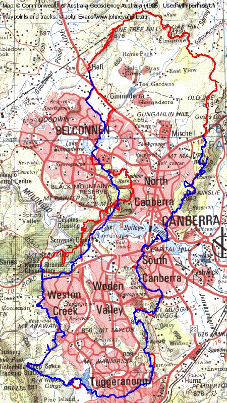
Trail Analysis
The Proposed walk route (this route been updated due to ongoing refinement) at www.tams.act.gov.au/__data/assets/file/0009/236277/Centrail_Proposed_Walk_Route_20111103_01.kmz is a bit of a disjointed shambles. Feeding it into GPSBabel produces 109 seperate OziExplorer track files; importing it directly into OziExplorer and saving the track file produces a single but disjointed track
Section 1: Parliament House to the Federal Highway, runs from track point 9548-9765 , then 9204-9304, then 102-241, then 530-984, then 242-529, then 985-1197 in the OziExplorer track file converted directly from the kml file. 19.4km. But I picked the segments out and joined them into one sequential track. We walked a preview on 23 Jun 12.
Section 2: Federal Highway to Mulligans Flat Road, runs from track point 1197-2144. 11.46km.
Section 3: Mulligans Flat Road to Hall, runs from track point 2144-2839, 3013-3697. There's an additional track up to One Tree Hill, from track point 2840-3012. 16.61km. I made a sequential track.
Section 4: Hall to the Cork Oak Plantation, runs from track point 3697-5238, then 5346-5402, then 10481-10504, then 5239- 5345, then 5403-5700. 25.8km. But I picked the segments out and joined them into one sequential track. We walked a near preview on 4 Aug 12.
Section 5: The Cork Oak Plantation to Stromlo Forest Park (indicative only, as passes through ongoing work in Arboretum), runs from track point 5700-6064. 12.2km. We walked a near preview on 4 Aug 12.
Section 6: Stromlo Forest Park to the Tuggeranong Wall, runs from track point 6064-6549, then 49-101, then 6550-8506. 20.27km. But I picked the segments out and joined them into one sequential track. We walked a preview on 14 Jul 12.
Section 7: The Tuggeranong Wall to Isaacs Ridge, runs from 8506-8583, then 10345-10480, then 9928-10344, then 8584-8813. 13.1km. But I picked the segments out and joined them into one sequential track. We walked a preview on 18 Aug 12.
Section 8: Isaacs Ridge to Parliament House, runs from 8813-8875, then 26-48, then 9766-9857, then 9927-9858, then 8876-9105, then 9137-9203, then 9106-9136, then 9305-9548. 16.1km. But I picked the segments out and joined them into one sequential track. We walked a preview on 18 Aug 12.
Back to Walks Index
This page last updated 29Jul13